


A geological map is a graphic representation of the geological features present in a particular region. It portrays the three-dimensional nature of the Earth's subsurface using a two-dimensional representation.
The primary purpose of a geological map is to illustrate the spatial relationships between different types of rocks, geological structures, and other relevant geological features such as faults, folds, and mineral deposits.
Geological maps are composed of several key components that convey important information to geologists and other users. These components include:
a) Legend: The legend provides a key to interpret the symbols, colors, and patterns used on the map. It explains the representation of different rock types, structures, and other geological features.
b) Stratigraphic Units: These units represent different layers of rocks arranged in chronological order, with the oldest at the bottom and the youngest at the top. Each unit is labeled and color-coded for easy identification.
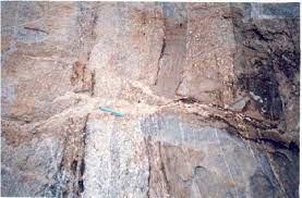
c) Structural Elements: Geological maps depict various structural elements such as faults, folds, joints, and fractures. These features help geologists understand the deformation history of the area and the potential for natural resources or geological hazards.
d) Topographic Information: Geological maps often include topographic contours, which represent the elevation and relief of the terrain. This information is crucial for understanding the relationship between geology and topography.
e) Geological Cross Sections: Cross sections are vertical profiles that provide a deeper understanding of the subsurface geology. They show the arrangement and relationships between different rock layers, structures, and other geological features.
Geological maps are created through a systematic process involving fieldwork, data collection, analysis, and cartographic representation. Here are the key steps involved in creating geological maps:
a) Fieldwork: Geologists conduct field surveys to gather data on the rock types, structures, and other geological features present in the area of interest.
They observe and record information about the lithology (rock types), stratigraphy (rock layers), and structural characteristics.
b) Data Collection: Various data collection techniques are employed during fieldwork, including rock sampling, measuring rock orientations (strike and dip), and documenting the locations of geological features.
Geophysical surveys, such as seismic profiling or ground-penetrating radar, may also be used to gather subsurface information.
c) Data Analysis: Once the field data is collected, geologists analyze and interpret the information to identify patterns, relationships, and geological boundaries.
This analysis helps in the classification of rock units, identification of structures, and understanding the geological history of the area.
d) Cartographic Representation: The interpreted data is then translated into a visual representation on a geological map. Geologists use standardized symbols, colors, and patterns to depict the different rock units, structures, and other geological features.
The map is typically accompanied by a legend and may include cross-sections and other supplementary information.
Geological maps have wide-ranging applications across various disciplines. Some of the key applications include:
a) Resource Exploration: Geological maps aid in the identification and evaluation of mineral deposits, hydrocarbon reservoirs, and groundwater resources. They provide valuable information on the distribution, composition, and geologic controls of these resources, aiding in exploration and resource management.
b) Engineering Projects: Geological maps are crucial for engineering projects, such as site selection for construction, tunneling, and infrastructure development. Understanding the subsurface geology helps engineers assess geological hazards, plan foundations, and design structures accordingly.
c) Environmental Assessment: Geological maps assist in assessing the environmental impact of mining activities, urban development, and land-use planning. They provide information about potential geological hazards, soil composition, and groundwater vulnerability.
d) Education and Research: Geological maps serve as educational tools for geology students, researchers, and educators. They facilitate the study of regional geology, tectonic processes, and the Earth's history. Researchers also utilize geological maps to identify areas for further investigation and scientific inquiry.
Kwara State, located in the north-central region of Nigeria, is renowned for its rich cultural heritage, agricultural potential, and natural resources. Among its many hidden treasures lies a diverse geological landscape that has fascinated researchers, geologists, and enthusiasts for decades.
In this article, we will delve into the geological map of Kwara State, uncovering its geological history, significant formations, and the valuable resources that contribute to its economic development.
Kwara State is situated within the Precambrian Basement Complex of Nigeria, which dates back to over 2 billion years ago. The region's geological history is characterized by a series of events, including the formation of the Nigerian shield and the Pan-African orogeny.
These processes have given rise to the diverse rock formations and structures that define the state's geology today.
Rock Formations
Basement Complex: The Basement Complex dominates Kwara State's geology and is composed of various types of rocks, including gneisses, granites, and migmatites.
These rocks are formed through intense heat and pressure, creating a strong and durable foundation for the region.
Schist Belts: Schist belts are present in certain areas of Kwara State, particularly in the northern part. These belts contain schists, which are metamorphic rocks that have undergone extensive alteration due to heat and pressure.
The schist belts provide insights into the geological processes that shaped the region's ancient past.
Sedimentary Basins: Kwara State is also home to sedimentary basins, such as the Ilorin Basin and the Bida Basin. These basins were formed by the accumulation of sediments over millions of years, resulting in the deposition of sandstones, shales, and limestone.
The sedimentary basins are of significant importance as they contain valuable resources, including hydrocarbons and groundwater.
Significant Geological Features:
Ifelodun Hills: Located in the southeastern part of Kwara State, the Ifelodun Hills are a prominent geological feature.
Composed mainly of granite and gneiss, these hills provide a breathtaking landscape and serve as a potential tourist attraction. The hills also offer valuable insights into the geological history of the region.
River Niger: While not entirely within Kwara State, the River Niger plays a vital role in shaping the state's geological features.
The river, which forms the state's northern border, has contributed to the formation of river valleys and floodplains. These areas are agriculturally productive and play a significant role in the state's economy.
Erosional Landforms: Throughout Kwara State, various erosional landforms can be found, including gorges, waterfalls, and caves.
These features are a result of the erosive forces of rivers and rainfall over time. Examples of such formations include the Owu Waterfall in Ifelodun Local Government Area and the Esie Museum Caves in Irepodun Local Government Area.
Economic Significance
Kwara State's geology holds immense economic potential, contributing to the state's development and livelihood of its residents. Key economic aspects related to its geological map include:
Solid Minerals: The state is blessed with an abundance of solid minerals, including limestone, granite, kaolin, and tantalite.
These minerals are essential for various industries, such as construction, ceramics, and metallurgy, creating employment opportunities and boosting the economy.
Hydrocarbons: The presence of sedimentary basins in Kwara State makes it a potential source of hydrocarbons.
Exploration activities for oil and gas are ongoing in the region, with the hope of discovering commercially viable reserves. If successful, this could significantly impact the state's economy.
Agriculture: The geological features of Kwara State, including the river valleys and floodplains, provide fertile soils suitable for agriculture.
The state is known for its production of crops like yam, maize, sorghum, and rice, contributing to Nigeria's food security and generating revenue through exportation.
The geological map of Kwara State offers a captivating glimpse into the region's ancient past, showcasing diverse rock formations, sedimentary basins, and erosional landforms. This geological diversity has paved the way for economic opportunities, with solid minerals, hydrocarbons, and agricultural resources driving the state's development.
By understanding and harnessing its geological riches, Kwara State can continue to thrive and build a sustainable future for its residents, all while preserving its geological heritage for generations to come.